Autodesk 15606-011408-9330 User Guide - Page 6
Planning and Designing Maps, Getting Familiar with Autodesk MapGuide Author .
 |
UPC - 606121429609
View all Autodesk 15606-011408-9330 manuals
Add to My Manuals
Save this manual to your list of manuals |
Page 6 highlights
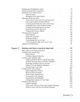
Working with Other Types of Spatial Data 112 Autodesk GIS Design Server Theme Data 112 Chapter 6 Planning and Designing Maps 115 Planning the Data 116 Planning Layers 116 Designing the Map 118 About Coordinate Systems 118 About Coordinate Precision 119 Choosing a Coordinate System 119 Creating a Design Spreadsheet 120 General Guidelines 121 Information You Need from Your Server Administrator . . . . . 122 Chapter 7 Getting Familiar with Autodesk MapGuide Author . . . . 123 Installing Autodesk MapGuide Author 124 Starting Autodesk MapGuide Author 125 About Map Window Files and Map Window XML Files . . . . 126 Introduction to the Program Window Layout 127 Using the Map Window Popup Menu 127 Using the Toolbar 130 Setting Preferences 132 Opening a Map 132 Moving Around on a Map 133 Zooming to a Location 134 Zooming to a U.S. Street Address or ZIP Code 134 Using Bookmarks to Save the Current Map View 135 Using the Map Explorer 135 Using the Design Tab 136 Using the View Tab 137 Changing the Width of the Map Explorer 138 Viewing Map Information 138 Measuring Distances 139 Selecting Map Features 140 Creating Buffers Around Map Features 141 Printing a Map 142 vi | Contents
-
 1
1 -
 2
2 -
 3
3 -
 4
4 -
 5
5 -
 6
6 -
 7
7 -
 8
8 -
 9
9 -
 10
10 -
 11
11 -
 12
12 -
13
-
14
-
15
-
16
-
17
-
18
-
19
-
20
-
21
-
22
-
23
-
24
-
25
-
26
-
27
-
28
-
29
-
30
-
31
-
32
-
33
-
34
-
35
-
36
-
37
-
38
-
39
-
40
-
41
-
42
-
43
-
44
-
45
-
46
-
47
-
48
-
49
-
50
-
51
-
52
-
53
-
54
-
55
-
56
-
57
-
58
-
59
-
60
-
61
-
62
-
63
-
64
-
65
-
66
-
67
-
68
-
69
-
70
-
71
-
72
-
73
-
74
-
75
-
76
-
77
-
78
-
79
-
80
-
81
-
82
-
83
-
84
-
85
-
86
-
87
-
88
-
89
-
90
-
91
-
92
-
93
-
94
-
95
-
96
-
97
-
98
-
99
-
100
-
101
-
102
-
103
-
104
-
105
-
106
-
107
-
108
-
109
-
110
-
111
-
112
-
113
-
114
-
115
-
116
-
117
-
118
-
119
-
120
-
121
-
122
-
123
-
124
-
125
-
126
-
127
-
128
-
129
-
130
-
131
-
132
-
133
-
134
-
135
-
136
-
137
-
138
-
139
-
140
-
141
-
142
-
143
-
144
-
145
-
146
-
147
-
148
-
149
-
150
-
151
-
152
-
153
-
154
-
155
-
156
-
157
-
158
-
159
-
160
-
161
-
162
-
163
-
164
-
165
-
166
-
167
-
168
-
169
-
170
-
171
-
172
-
173
-
174
-
175
-
176
-
177
-
178
-
179
-
180
-
181
-
182
-
183
-
184
-
185
-
186
-
187
-
188
-
189
-
190
-
191
-
192
-
193
-
194
-
195
-
196
-
197
-
198
-
199
-
200
-
201
-
202
-
203
-
204
 |
 |
