Garmin GPSMAP 188C Owners Manual - Page 52
To change the highway perspective scale
 |
UPC - 753759031923
View all Garmin GPSMAP 188C manuals
Add to My Manuals
Save this manual to your list of manuals |
Page 52 highlights
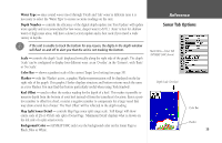
Reference Numbers Page/ Highway Page Numbers Page with the middle data field split into four small data fields. Current Nav Point Data Fields Route Waypoints Desired Track Line Current Position 42 Zoom Scale Highway Page Numbers Page The Numbers Page provides a quick reference for the important data you want to display. The default page displays three large, user-selectable data fields showing a compass ribbon, speed and current position coordinates. You may also choose to show the three data fields in large lettering for better readability or you may 'split' any or all of the data fields to show 4 smaller data fields. For detailed instructions on changing the data fields and layout of the Numbers page, see pages 26-28. Highway Page When a Go To, TracBack, or route has been activated, the GPSMAP 188/188C/238 Sounder's Highway Page provides digital and graphic steering guidance to the destination. The top half of the Highway Page features user-selectable data fields that display useful navigation data. Additionally, a compass ribbon is displayed to show your current heading along with a dark, vertical bar indicates the bearing to your course. To stay on course, steer towards the black vertical indicator (or arrows) until it lines up with the red bar in the middle. The bottom section of the screen provides visual guidance to the waypoint on a graphic highway display. The line down the center of the highway represents your desired track line. As you head toward your destination, the highway perspective moves to indicate your progress to the waypoint and which direction you should steer to stay on course. If you are navigating a route, the Highway Page shows each route waypoint in sequence connected by a red "road" with a yellow line down the middle, which is your desired track line. Nearby waypoints not in the active route can also be displayed. The highway perspective scale may also be zoomed in or out to display a larger or smaller view of the highway. Five settings are available from 1X to 16X, with a default setting of 8X. To change the highway perspective scale: 1. Press the ZOOM IN or ZOOM OUT key to select the desired setting.
-
 1
1 -
2
-
3
-
4
-
5
-
6
-
7
-
8
-
9
-
10
-
11
-
12
-
13
-
14
-
15
-
16
-
17
-
18
-
19
-
20
-
21
-
22
-
23
-
24
-
25
-
26
-
27
-
28
-
29
-
30
-
31
-
32
-
33
-
34
-
35
-
36
-
37
-
38
-
39
-
40
-
41
-
42
-
43
-
44
-
45
-
46
-
 47
47 -
 48
48 -
 49
49 -
 50
50 -
 51
51 -
 52
52 -
 53
53 -
 54
54 -
 55
55 -
 56
56 -
 57
57 -
58
-
59
-
60
-
61
-
62
-
63
-
64
-
65
-
66
-
67
-
68
-
69
-
70
-
71
-
72
-
73
-
74
-
75
-
76
-
77
-
78
-
79
-
80
-
81
-
82
-
83
-
84
-
85
-
86
-
87
-
88
-
89
-
90
-
91
-
92
-
93
-
94
-
95
-
96
-
97
-
98
-
99
-
100
-
101
-
102
-
103
-
104
-
105
-
106
-
107
-
108
-
109
-
110
-
111
-
112
-
113
-
114
-
115
-
116
-
117
-
118
-
119
-
120
-
121
-
122
-
123
-
124
-
125
-
126
-
127
-
128
-
129
-
130
-
131
-
132
-
133
-
134
 |
 |
